Technology has integrated itself into our lives so inextricably - to the extent of becoming an extension of ourselves, lulling, perhaps dulling us into relying so heavily on the gizmos we constantly find in our hands, or at our fingertips - scanning a screen to give us the information we need. A glowing screen has replaced paper. Although, the irony of lamenting on a weblog isn't lost on me, I brought this up because it pertains to this narrative - do we even carry paper maps anymore? I haven't for years now. I should, they are essential, but I haven't been. I have been relying too much on my gadgets. My Ultrabook to plan my itineraries - translating them into meandering routes, and a scattering of way-points, before sending all that data to my GPS devices - which have been my rudders, steering me collectively through over 120,000 miles of wandering travels over the past 8 years. Evidently, this has worked pretty well for me over the years - until it didn't. :)
Adventure begins when one leaves their backyard. Northern California - even around the Shasta area is still my backyard. I consider Shasta home after all. Adventure can still be found here, if I had decided to go way off the beaten track, but I didn't this time around. The plan was to visit Crater Lake first - come in the South entrance, snap a few photographs and exit the north entrance, to find the Aufderheide scenic byway (for off the beaten track fun). Crater Lake was hardly busy at all, it was still early enough in the morning and not a lot of souls were stirring yet. Chilly as it almost always is, but still pleasant. Not a cloud in the sky, although I would have preferred some of those white fluffy ones to be floating around. The lake was mostly calm, and reflective in that deep, deep blue hue, echoing the thoughtful and introspective state of mind it instills.
Riding a motorcycle is the closest you will ever get to flying, without ever leaving the ground.
Showing posts with label Mt. Hood. Show all posts
Showing posts with label Mt. Hood. Show all posts
Friday, July 22, 2016
Monday, July 29, 2013
Wandering the Cowboy Country of the Western U.S. - Chapter 3: The Mountain Hideaway.
The culminating Chapter, of the journey from Chapter 1, and Chapter 2.
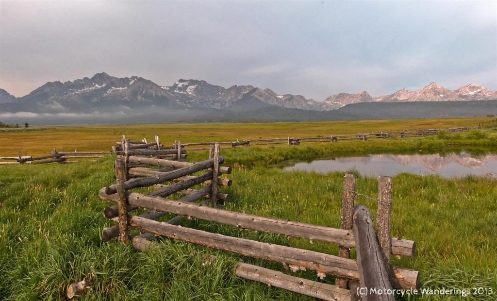
I love Mountain hideaways. They are amazing not only for hiding out from the Zombie Apocalypse, but pretty much for hiding away from almost everything including all those worries, chores, stresses and the busy-bee activities of your day to day life. It's the perfect hideaway from the Zombie that one becomes in real day to day life!
Stanley is one such hideaway, I have come here twice now and have loved it both times. Although, this time the weather was starkly different from last, but it just added a different element to the appeal of this place. This morning the sunrise was greeted by moody skies, still lingering after last night's storm. The previous evening, I had enjoyed hearing the moo'ing of the cows right up to sunset. They had moved on this morning or had been herded back to where ever they rest for the night.
Thursday, August 2, 2012
If You Hinkle Tinkle in Packwood - We See Your Johnson!
Chapter 3 of the Ring of Fire Tour of the Pacific North West, for the Packwood RTE.
July 6th & 7th, 2012.
I don't get the whole "I stayed at a Holiday Inn Express last night". If I was staying at a somewhat comparable hotel I would rather stay at a Best Western Plus (or the Best Western Plus in Sutherlin, OR). Freshly baked home made cookies of all kinds - "free" for the taking and a made to order cooked breakfast in the morning. Good Morning Oregon!
We were heading towards Sweet Home. No, not home, sweet home, but Sweet Home, OR. About 411 miles to cover today and we took the easy start in the morning and slabbed it up I-5 to the Brownsville exit for Hwy 228. Despite oppressive enforcement of the retarded speed limits in this state, I was surprised to see how easy it was to find rabbits on the interstate. Don't mind us, just a couple of Dawgs chasing rabbits..
Our first stop was in Crawfordsville, as I spotted this covered bridge over the Calapooia River. Built in 1932, it was bypassed in 1963 and is now a pedestrian bridge across the river. There is also a park next to the bridge with picnic tables and a fire pit for you Iron Butt Motel aficionados.
Subscribe to:
Posts (Atom)


